

Myanmar :: Geography
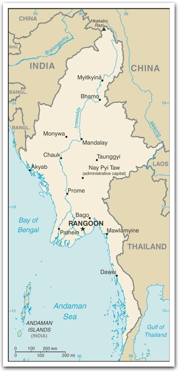 Location: Southeastern Asia, bordering the Andaman Sea and the Bay of Bengal, between Bangladesh and Thailand
Area: 678,500 sq km
(land: 657,740 sq km; water: 20,760 sq km)
Terrain: lowland; gently undulating central plateau contains water catchment area and nature preserve
Elevation extremes
lowest point: Andaman Sea 0 m;
highest point: Hkakabo Razi
the highest point in Southeast Asia
Major river: Irrawaddy River, 2170 km
Land use
arable land: 14.92%;
permanent crops: 1.31%;
other: 83.77% (2005)
Irrigated land: 18,700 sq km (2003)
Natural resources: petroleum, timber, tin, antimony, zinc, copper, tungsten, lead, coal, some marble, limestone, precious stones, natural gas, hydropower
Climate: tropical monsoon;
June to September: cloudy, rainy, hot, humid;
December to April: less cloudy, scant rainfall, mild temperatures, lower humidity
Environment issues: (1) deforestation; (2) industrial pollution of air, soil, and water; (3) inadequate sanitation and water treatment contribute to disease
Source of statistics: World Factbook, updated August 2007