

Singapore :: Geography
 Location: Southeastern Asia, southern tip of the Malaysia Peninsula
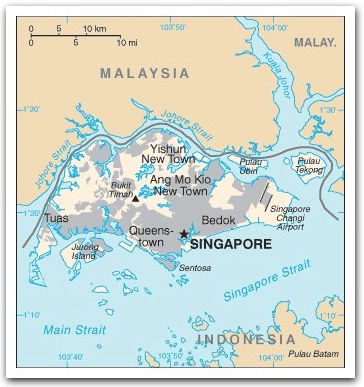
Comprises one main island and some 63 offshore islands; the larger offshore islands are Pulau Tekong, Pulau Ubin, Sentosa and Jurong Island
Area: 692.7 sq km
(land: 682.7 sq km; water: 10 sq km)
Terrain: lowland; gently undulating central plateau contains water catchment area and nature preserve
Elevation extremes
lowest point: Singapore Strait 0 m;
highest point: Bukit Timah
Land use
arable land: 1.47%;
permanent crops: 1.47%;
other: 97.06% (2005)
Natural resources: fish, deepwater ports
Singapore is the largest port in Southeast Asia and one of the busiest in the world. Its strategic location connects the Indian Ocean to the South China Sea.
Climate: equatorial climate; warm and humid all year round; rain falls throughout the year
Environment issues: (1) industrial pollution; (2) limited natural fresh water resources; (3) limited land availability presents waste disposal problems; (4) seasonal smoke/haze resulting from forest fires in Indonesia
Water sources: (1) water from local catchments; (2) imported water from Johor, Malaysia; (3) reclaimed water called NEWater; (4) desalinated water through reverse osmosis
Source of statistics: World Factbook, updated August 2007