

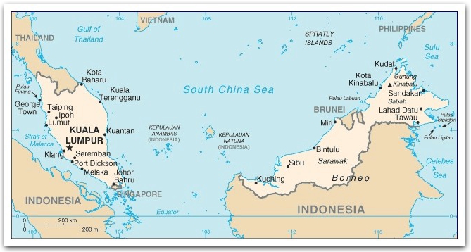
Malaysia :: Geography
|
Capital city: Kuala Lumpur
Note: Putrajaya, a planned city, acts as the government administration centre/capital of Malaysia.
Location: Southeastern Asia,
(1) peninsular Malaysia,
(2) East Malaysia (states of Sabah and Sarawak in the northern one-third of the island of Borneo),
Area: 329,750 sq km
(land: 328,550 sq km; water: 1,200 sq km)
Terrain: coastal plains rising to hills and mountains
Elevation extremes
lowest point: Indian Ocean 0 m;
highest point: Mount Kinabalu (Malay: Gunung Kinabalu)
Major rivers:
(1) Rajang (longest at 563 km) in Sarawak, East Malaysia and
(2) Pahang (459 km) in Peninsular Malaysia
Land use
arable land: 5.46%;
permanent crops: 17.54%;
other: 77% (2005)
Irrigated land: 3,650 sq km (2003)
Natural resources: tin, petroleum, timber, copper, iron ore, natural gas, bauxite
Climate: tropical;
April to October: southwest monsoon;
October to February: northeast monsoon
Natural hazards: flooding, landslides, forest fires
Environment issues: (1) air pollution from industrial and vehicular emissions; (2) water pollution from raw sewage; (3) deforestation; (4) smoke/haze from Indonesian forest fires
Source of statistics: World Factbook, updated August 2007